Guiding city growth
The Official Plan defines a city structure that helps us decide which areas of Mississauga can support more growth. It directs growth in a way that is efficient, cost-effective, protects the environment and fits within the existing uses of each area.
Understanding the city structure
The city structure establishes where population and job growth is directed. It is made up of areas with different land uses such as higher and lower density residential use, employment, industrial and open space. Areas are further broken down into multiple zones in the Zoning By-law, each with their own specific rules about land use and building.
Our city structure includes the following areas:

Downtown Core
The Downtown Core has the highest densities, tallest buildings and greatest mix of uses.
 Growth Centres
This area includes Uptown, Fairview, Cooksville and Hospital. These areas have a mix of uses but with lesser densities and heights than the Downtown Core.

Growth Nodes
These areas mix residential and business uses with densities and heights lower than the Downtown Core and Growth Centres but higher than the rest of the city. The Central Erin Mills, Malton, Meadowvale, Rathwood-Applewood, Sheridan and South Common Growth Nodes are built around indoor malls with additional policies to guide redevelopment.
 Neighbourhoods
 Employment Areas
These areas allow for a variety of employment uses including industrial and warehousing at low densities and heights.
 Special Purpose Areas
These areas have a unique role in the city and have special rules on land use. Examples include Pearson International Airport and the University of Toronto Mississauga.
Learn more about the city structure with the Mississauga Official Plan city structure map.
Planning growth strategically
We direct growth to Strategic Growth Areas. These include the Downtown Core, Growth Centres, Growth Nodes and Major Transit Station Areas (MTSAs).
MTSAs are areas within a 10-minute walk of a GO train or rapid transit stop. They are governed by the Province and have different zoning rules, such as allowing taller buildings for an even larger concentration of people and jobs.
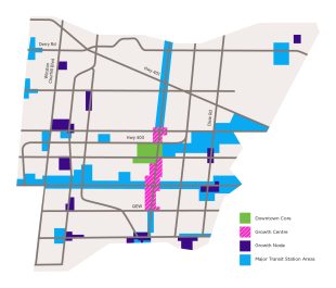
We direct growth to these areas to utilize existing infrastructure, like roads, sewers or transit corridors. It also helps us deliver community services like parks, community centres and fire stations more efficiently.
Less growth is directed to Neighbourhoods. These areas will mostly see gentle growth through new housing options such as fourplexes and additional residential units like garden suites. This helps to increase the housing supply, while maintaining the original vision for the area. It also provides other benefits like rental income opportunities for property owners.
Delivering services and maintaining infrastructure
New development helps pay for infrastructure and services through different growth charges, including development charges. The City distributes a portion of development charges to Peel Region, Metrolinx and school boards for their own infrastructure and service upgrades.
Development doesn’t always mean an immediate delivery of additional services though. Sometimes land and funding for amenities like parks, community centres and fire stations are secured during the early stages of development but these amenities don’t get built until later on.
The City uses master plans for long-range planning of all services and infrastructure maintenance, including: