Background
According to the City of Mississauga’s Strategic Plan, one of the City’s strategic goals is to build and maintain its infrastructure for its citizens and for generations to come. A sound, functional and attractive infrastructure is integral in completing its neighbourhoods, as we build a City for the 21st century.
Sections of the municipal road network require rehabilitation as per the City’s two-year program. Required work includes removal and replacement of existing asphalt, improvement/installation of subgrades, replacement of concrete curbing and adjustments to manholes and catchbasins.
Project details:
- Estimated cost: $26.2 million
- Contractor
- Four Seasons Site Development
- Associated Paving
- Furfari Paving
Objectives and benefits
This project allows for the rehabilitation of roadways at an optimum point in their life cycle, such that the life of the road will be extended without extensive road reconstruction. This reduces future maintenance and capital cost. This also increases the averaged pavement condition index of the municipal road network, therefore contributing to the effective movement of people and goods, and improving road safety.
Locations:
- Admiral Boulevard: Hurontario Street to Kennedy Road
- Aerowood Drive: Ambler Drive to Kamato Road
- Argentia Road: Derry Road to Mississauga Road
- Britannia Road East: Hurontario Street to Kennedy Road
- Burnhamthorpe Road: Creditview Road to Credit River Bridge
- Creditview Road: Britannia Road to Falconer Drive
- Creditview Road: Falconer Drive to Old Creditview Road
- Eglinton Avenue West: Creditview Road to Terry Fox Way
- Eglinton Avenue West: Erin Mills Parkway to Mississauga Road
- Haultain Court: Maingate Drive to End
- Lakeshore Road West: Lorne Park Road to Southdown Road
- Maingate Drive: Eglinton Avenue to Matheson Boulevard
- Turney Valley Drive: Argentia Road to Mississauga Road
- Winston Churchill Boulevard: Dundas Street West to Burnhamthorpe Road
- Winston Churchill Boulevard: Eglinton Avenue to Derry Road
Project details
- Estimated cost: $14.5 million
- Architect: Jain & Associates
- Contractor
- Hermans Contracting
- Mopal Construction
- Equipment: Aluminous Lighting Products and Spectalume Lighting
Background
According to the City of Mississauga’s Strategic Plan, one of the City’s strategic goals is to build and maintain its infrastructure for its citizens and for generations to come. A sound, functional and attractive infrastructure is integral in completing its neighbourhoods, as we build a City for the 21st century.
Lighted pathways within the parks system are used by pedestrians, cyclists, roller bladers and serve as pedestrian linkages connecting centre of activity, such a schools, public facilities, natural areas, institutions, shopping centres and connections to transportation routes.
Light standards along the City’s parks and trails are past their serviceable life. Some surfaces of pathways are deteriorating and are in need of repair or complete replacement.
Objectives and benefits
The electrical lighting infrastructure will be replaced, including underground wiring and conduit, poles, ballasts, bulb fixtures, etc. Rehabilitation of the pathway will involve reconstruction of pathway drainage and asphalt surface.
The refurbished lighted pathways will provide safe park access and encourage participation in leisure and recreation activities within park settings.
High efficiency bulbs and ballasts with code compliant supply systems will reduce energy consumption.
This project has environmental and safety benefits such as energy savings and avoiding hazardous situations.
Status
- Consultant RFP, June 2009 – Complete
- Pre-engineering and schematics, July 2009 – Complete
- Design development, August 2009 – Complete
- Tendering, November 2009 to February 2010 – Complete
- Construction Phase 1 (Wards 1, 2, 3, 4, 5, 6, 7), December 2009 – Complete
- Construction Phase 2 (Wards 8, 9, 10, 11), March 2010 – Complete
- Construction Completion, November 2010 to January 2011 – Complete
Locations complete
- Arbour Green
- Beechwood Park
- Ben Machree Park
- Bloor Athletic Field
- Bonnie Brea
- Brandon Gate Park
- Brentwood Park
- Brookmede Park
- Burnhamthorpe Library Grounds
- Derry Greenway
- Douglas Kennedy Park
- Eden Grove
- Eden Woods
- Elmcreek Park
- Fred Halliday Memorial Park
- Glen Eden Park
- Glendenning Park
- Golden Orchard Park
- Gordon Lummiss Park
- Hawkins Glen
- Hiawatha Park
- Huron Park
- J.C. Saddington Park
- J.J. Plaus
- Kennedy Park
- Kindree Gate
- Kings Masting Park
- Kogaydwin Trail
- Lake Aquitaine
- Lake Aquitaine Trail
- Lake Wabukayne
- McCauley Green
- McKenzie Park
- Meadow Green
- Meadowvale Sports Park
- Millgrove Park
- Millgrove Trail
- Northwood Park
- Pinecliff Park
- Pinetree Grove Park
- Plowmans Park
- Promenade Meadows
- Rathwood District Park
- Rayfield Park
- Richard FC Mortenson Park
- Richards Memorial Park
- Sandgate Park
- Sawmill Valley Trail
- Serson Park
- Settlers Green
- Shalebank Hollow
- Shaver Trail
- Shelby Park
- Sheridan Creek Trail
- Springbank Meadows
- Springfield Park
- Spruce Park
- Stillmeadows Park
- Stonebrook Park
- Taffey Park
- Thornlodge Park
- Trappers Green
- Turney Woods
- Wakefield Common Park
- Westwood Park
- Wildwood Park
- Windwood Park
- Windy Hollow
- Woodeden Park
- Woodgreen Park
- Woodhurst Heights
- Woodington Green
- Woodland Chase Park
Background
According to the City of Mississauga’s Strategic Plan, one of the City’s strategic goals is to build and maintain its infrastructure for its citizens and for generations to come. A sound, functional and attractive infrastructure is integral in completing its neighbourhoods, as we build a City for the 21st century.
New sections of sidewalks are required to meet provincial guidelines for a fully accessible transit network.
Project details:
- Estimated cost: $2.4 million
- Contractor: VBN Paving Limited
Objectives and benefits
This project will result in a fully accessible sidewalk network to all transit stops. Benefits include pedestrian safety and accessibility for all transit users. As part of the City’s multi-modal transportation network, the project also contributes to the reduction of greenhouse gases (transit-supportive) and active transportation (public health benefits).
Locations:
- Bonhill Road South: Van Deemter Court to Neetherhart Road
- Britannia Road South: Avebury Road to Hurontario Street
- Britannia Road South: Ninth Line to Tenth Line
- Britannia Road South: Winston Churchill Boulevard to Greensboro Drive
- Brunel Road North: Kennedy Road to Whittle Road
- Cardiff Boulevard North/South: Derry Road to Lormiar Drive (west leg)
- Columbus Road East: Midway Boulevard to Derry Road
- Derry Road South: Edwards Boulevard to Airport Road
- Derry Road South: McLaughlin Road to Hurontario Street
- Dixie Road West: Crestlawn Drive to Hickory Drive
- Freemount Boulevard East: Britannia Road to Cantay Road
- Hadwen Road West: Meyerside Drive to Bonhill Road
- Kennedy Road East: Coopers Avenue to Brunel Road
- Meyerside Drive North: Netherhart Road to Bonhill Road
- Midway Boulevard South: Columbus Road to Dixie Road
Background
According to the City of Mississauga’s Strategic Plan, one of the City’s strategic goals is to build and maintain its infrastructure for its citizens and for generations to come. A sound, functional and attractive infrastructure is integral in completing its neighbourhoods, as we build a City for the 21st century.
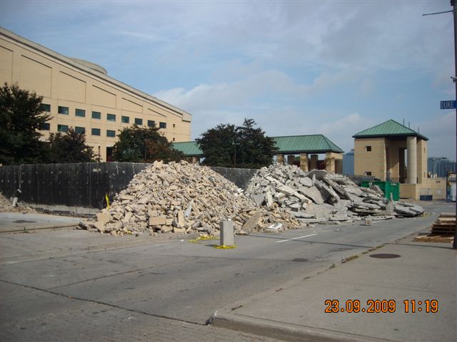
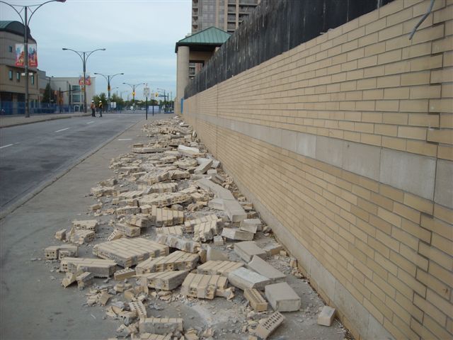
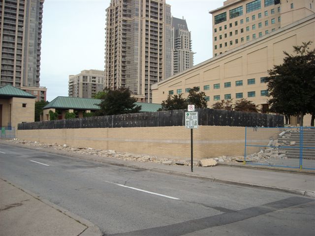
Some of the City’s aging road noise attenuation barriers are in disrepair and require replacement. This project involves removal and disposal of existing barriers, installation of new concrete footings, installation of new concrete noise barriers and property re-grading.
Project details:
- Estimated cost: $4 million
- Contractor: International Fence Limited
Objectives and benefits
Replacement of the noise attenuation barriers will ensure public safety and return this infrastructure to a state of good repair. Beyond the aesthetic community improvement, it will ensure compliance with the Ministry of Environment noise attenuation standards.
On January 12, 2011 an additional 14 noise wall projects were approved by the Federal and Provincial governments.
Approved locations:
- Burnhamthorpe Road, north side – little Etobicoke Creek to Corbet Drive
- Burnhamthorpe Road, north side – Elora Drive to Confederation Pkwy
- Burnhamthorpe Road, north side – Tomken Road to Westminister Drive
- Burnhamthorpe Road, north side – Westminster Drive to Cawthra Road
- Burnhamthorpe Road, north side – Golden Orchard Drive to Little Etobicoke Creek
- Burnhamthorpe Road, north side – Cawthra Road to Wilcox Road
- Burnhamthorpe Road, south side – Golden Orchard Drive to Little Etobicoke Creek
- Confederation Parkway, west side – Hillcrest Road south 220 metres
- Eglinton Avenue West, north side – Guildwood Way to Mariner Court
- Eglinton Avenue West, south side – Wayside Court to Wainscot Drive
- Mavis Road, west side – Burnhamthorpe Rd. to Hwy 403
- Mavis Road, west side – Dundas Street West to Paisley Boulevard
- Rathburn Road West, north side – Corbet Drive to Little Etobicoke Creek
- Rathburn Road West, north & south side – Queensbridge Drive to Sawgrass Park
- Rathburn Road West, north side – Mavis Road to Wakefield Crescent
- Rathburn Road East, south side – Tomken Road to Corbet Drive
- Rathburn Road West, south side – Mavis Road to Queensbridge Drive
- Rathburn Road East, Little Etobicoke Creek to 80m east of Hickory Drive
- Rathburn Road East, north side – Wyatt Court to Golden Orchard Drive
- Tomken Road, east side – Willowbank Trail to Eastgate Parkway
- Burnhamthorpe Road West, south side – Credit River to 140 m west of Promontory Crescent
- Burnhamthorpe Road west, north side – Credit River to 200 m west of Promontory Drive
- Dundas Street west, south side – 360 m west of Cedarglen Gate to 170 m east of Cedarglen Gate
- Eglinton Avenue west, south side – Founders walk to Empire Crescent
- Eglinton Avenue west, north side – Heritage Hills Boulevard to 30 m east of Heritage Hills
- Eglinton Avenue west, south side – Heritage Hills Boulevard to Founders Walk
- Eglinton Avenue west, south side – Penhallow Road to Wayside Court
- Eglinton Avenue west, north side – Silverthorne Crescent to Heritage Hills Boulevard
- Eglinton Avenue west, south side – Wainscot Drive to Millworks Crescent
- Rathburn Road East, south side – Cawthra Road to Willowbank Trail
- Rathburn Road east, north side – Tomken Road to Starlight Crescent
- Rathburn Road east, north side – Wyatt Court to Hickory Drive
- Robert Speck Parkway, east side – Burnhamthorpe Road east to 125 m north of Meadows Boulevard
- Tomken Road, west side – Burnhamthorpe Road east to Eastgate Parkway
According to the City of Mississauga’s Strategic Plan, one of the City’s strategic goals is to build and maintain its infrastructure for its citizens and for generations to come. A sound, functional and attractive infrastructure is integral in completing its neighbourhoods, as we build a City for the 21st century.
Wastewater facilities, which are designed to remove and collect sediments and other contaminants from local urban stormwater runoff, are very near capacity for sediment collection. Major maintenance is essential to restore stormwater quality treatment function and performance of the facility; to protect the downstream natural water resources and aquatic contaminants associated with urban runoff; and to extend the useful life of the facility.
Project details
- Estimated cost: $500,000
- Consultants: Sernas & Associates Limited
- Contractors: Hollandia Land and Environmental Services
Objectives and benefits
Dredging and rehabilitating the existing stormwater management pond facilities will remove and dispose of accumulated sediments and will re-instate aquatic and upland vegetative plantings within the pond block.
Stormwater quality treatment function will be restored and downstream natural water resources and the aquatic environment will be protected from the release of harmful sediments and other contaminants associated with urban runoff.
The useful life of these facilities will be extended and the City’s capital investment will be protected. Environmental benefits include the protection of downstream aquatic life, habitat, and surface water resources.
This project improves efficiency of the transportation network specifically related to local and inter-regional public transit vehicles in the Mississauga City Centre.
Project details
- Estimated cost: $5.5 million
- Consultant: McCormick Rankin Corporation
- Contractor
- Rathburn Road: Graham Brothers
- Mavis Road: Graham Brothers
Background
According to the City of Mississauga’s Strategic Plan, one of the City’s strategic goals is to build and maintain its infrastructure for its citizens and for generations to come. A sound, functional and attractive infrastructure is integral in completing its neighbourhoods, as we build a City for the 21st century.
The Rathburn Road Transit Priority Measures project has been updated with an interim design to provide for new bus stations and shelters along the existing boulevards of Rathburn Road from Hurontario Street to Duke of York Boulevard to accommodate the need to facilitate the transit ridership demands.
This interim design/construction is in advance of the future re-allocation of existing road space between Hurontario Street and Duke of York Boulevard in the Mississauga City Centre that will allow for installation of median reserved bus lanes on Rathburn Road. This project incorporates the existing Mississauga Transit City Centre Terminal as well as the GO Transit Station Gate Terminal.
Objectives and benefits
This project improves efficiency of the transportation network specifically related to local and inter-regional public transit vehicles in the Mississauga City Centre. Providing priority to public transit will attract additional transit ridership and reduce automobile trips, with the aim of ultimately reducing greenhouse gas emissions.
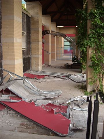
Redevelopment will address current deficiencies in the areas of accessibility, safety and energy consumption. Work will include resurfacing the floors in high traffic areas, adding non-slip coating to floors, and reduced energy consumption through more efficient power and communication routing.
Project details
- Estimated cost: $2.7 million
- Project management: SMG Canada
- Architect: Parkin Architects
- Contractor: PCL Contractors
Background
According to the City of Mississauga’s Strategic Plan, one of the City’s strategic goals is to build and maintain infrastructure for its citizens and for generations to come. A sound, functional and attractive infrastructure is integral in completing its neighbourhoods, as we build a City for the 21st century.
The Hershey Centre SportZone is the City’s major public assembly facility, comprised of a 5,400 seat spectator arena, a three ice pad community arena, indoor regulation soccer field, triple gymnasium, gymnastics centre, outdoor sport fields and expansive parking area. It is home to Mississauga cultural and sports organizations, boasting an attendance of over 3 million users per year.
Since it opened in 1998, there have been minimum requirements for facility design and long-term Capital upgrades. Today’s more stringent standards have resulted in the need to upgrade multiple components of the Hershey SportZone’s infrastructure, such as installation of power and communications throughout the complex to improve public safety and meet a range of new activities; redevelopment and construction of public facility operation areas including equipment and fixtures; upgrading the kitchen; painting, flooring and other improvements in the public and back-of-house areas. Redevelopment will extend the lifecycle of the facility while correcting deficiencies in safety and accessibility.
Objectives and benefits
As host of the 2011 Memorial Cub and the combative arts competition of the 2015 Pan/Parapan American Games, the Hershey SportZone will see a dramatic increase in attendance. Redevelopment will address current deficiencies in the areas of accessibility, safety and energy consumption. Benefits of this redevelopment, to the community include: the ability to better serve Mississauga’s aging population by resurfacing the floors in high traffic areas and adding non-slip coating to floors; reduced energy consumption through more efficient power and communication routing; increase usability by the community through improvements to technical and production areas; increase ability for multi-lingual messaging to facilitate use by multicultural groups.
Details and project schedule for the redevelopment of Civic Square (now known as Celebration Square).
Background
According to the City of Mississauga’s Strategic Plan, one of the City’s strategic goals is to build and maintain its infrastructure for its citizens and for generations to come. A sound, functional and attractive infrastructure is integral in completing its neighbourhoods, as we build a City for the 21st century.
The City’s Civic Square is the premier location for large events, connecting residents and community groups through arts, culture and heritage. The “My Mississauga” Events Program including Canada Day attracted over 250,000 residents in 2008.
Existing physical and mechanical infrastructure including the outdoor skating rink, fountain, waterfall and waterproof membrane are at life expectancy. Constructed as two separate spaces separated by City Centre Drive, the square is not capable of supporting large events. Performance infrastructure including stage, sound and lighting are inadequate.
Project details
- Estimated cost: $40 million
- Architect: CS&P Architects
- Contractor: PCL Constructors
- Funding Program: ISF Funded Project
- Drawings: Construction Photo
Objective and benefits
The City Centre has seen significant residential growth over the past five years creating a more vibrant downtown. Revitalization of the square has been proposed following extensive public consultation. An aging infrastructure will be replaced, including the skating rink and fountain and the Civic Square will be developed as an outdoor community centre with amenities to support “My Mississauga” cultural and heritage events. Based on the design concept, the square is expected to achieve recognition as one of the great public spaces in the Greater Toronto Area (GTA).
The principles of placemaking have been incorporated in the design. The plan provides for one large square, an interactive water feature converting to a skating rink in winter, a permanent stage with performance infrastructure, a market area to support cultural events, and upgrades to the amphitheatre to address deficiencies.
A linear digital media wall in line with the permanent stage will support events, provide interactive art capability and opportunity for commercial advertising. The design will incorporate improved access to City Hall and linking of events on the square to the Great Hall and the Central Library.
Design concepts and features
One Larger Square
- Link the two squares together by removing sections of existing walls at the southern edge of the Civic Square and improving the grade transitions by redesigning the steps from the Square to the City Centre Drive Boulevard
- Redesign City Centre Drive as a street through a pedestrian precinct to serve as a route that moves vehicular traffic that can be easily closed during event programming
Expansion of the Skating Rink
- Double the size of the existing ice surface on the square and replace the existing outdated ice refrigeration unit with new dependable ice-making technology to allow a longer skating season and greater certainty to maintain ice during the season
Interactive Water Feature
- Replace the existing reflecting pool on the Civic Square with a zero-edge water feature, meaning that the surface of the new water feature will be at the same grade as the surrounding square, using recessed water jets provided, thereby maximizing flexible use and programming of the square
Redeveloped Amphitheatre
- Open up the amphitheatre by removing walls that currently separate it from the square and raising the low floor to connect it with the redesigned square; construct washrooms and a greenroom to support regular event programming for up to 350 people and install a permanent shade structure
Large Open Lawn
- Reconfigure the lawn surface on the Central Library Square at a level grade condition with proper drainage to host activities
Permanent Stage
- Develop a permanent outdoor stage with a sound system at the southern boundary of the Central Library Square to support My Mississauga event programming and all major event programming year round. This location would require the removal of the existing water fountains.
Media Wall
- Install a media wall along the southern boundary of the Central Library Square, which could incorporate programmable and interactive digital arts
Market Area
- Establish an area for a variety of specialized seasonal open air markets with approximately 40 vending stalls on the Central Library Square (a section of the market area will be protected by a permanent open-sided roof structure – any new market development would be done in consultation with the Mississauga Central Lion’s Club
Status
December 2011
Information below is current as of the date identified. Information, including the date and status for each phase may change throughout the project. Updates will be posted once a month.
Project timeline
- Consultant & contractor awarded, July 2009 – Complete
- Design development, August 2009 to March 2010 – Complete
- Project presentations, August 2009 to December 2009 – Complete
- Demolition tender – August 2009, – Complete
- Mobilization to site, September 2009 – Complete
- Construction start, October 2009 – Complete
- Construction completion, May 30, 2011 – Complete
- Open to the public, June 8, 2011 – Complete
- Official opening event, June 22, 2011 – Complete